
UPDATE: More snow on the way to Ireland - see detailed snow map for your area



Snow is likely to fall once again on Monday evening and overnight with 7cm possible in some spots
Ireland is bracing itself for even more snow on Monday night amid further weather warnings from Met Éireann.
Some parts of the country have already seen 40cm of snow over the weekend but the deluge may not be over with further flurries likely for counties unaffected the first time around.
Donegal is now likely to see 7cm of snow in parts with other areas along the west coast and north west midlands also looking likely to welcome similar amounts.
Other parts of the country could see between 3 and 5cm of snow with a prolonged spell of freezing temperatures making a thaw next to impossible until Friday.
While a Met Éireann snow-ice warning for the entire country ends at noon on Tuesday, a separate Status Yellow low temperature/ice warning for Ireland will remain in place until midnight on Thursday night.
Met Éireann warns of "very cold nights with widespread frost, ice and lying snow. Temperatures struggling to get above freezing during the day." Night-time temperatures could touch -8 or -9 degrees overnight in some sheltered areas and -3 or -4 more widely.
Potential impacts are "hazardous travelling conditions on roads and underfoot and travel disruption."
Meanwhile, Cathal Nolan from Ireland's Weather Channel has issued his own set of warnings and a weather map pinpointed where the heaviest snow will fall on Monday night and Tuesday morning.
"Further to our weather warning for snowfall yesterday an updated STATUS ORANGE weather warning for additional snowfall has been issued by Ireland Weather Channel, with accumulations of between 5-7cm possible this evening and overnight across certain parts of the country, with 2-3cm possible right across the country, excluding immediate coastal areas of the southeast.
"Commencing at 4pm in Donegal, before extending across the country and remaining in place until 10pm when the main body of precipitation clears away to the southeast. This polar low has the potential of bringing moderate accumulations of snow to parts of Donegal, Leitrim, Sligo, Mayo, Galway, Roscommon, Longford and North Westmeath, with parts of West Limerick, East Kerry and North Cork also included once more, as well as other upland areas in Tipperary, Clare, Laois and Offaly.
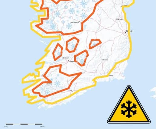
"We are also issuing a country wide Status Orange weather warning for Ice and Low temperatures with ice becoming an issue right across the country once again, with treacherous driving conditions expected overnight and into tomorrow, with temperatures falling back as low as -5 or -6 degrees Celsius in some areas. This will lead to challenging conditions for motorists once again," Cathal's forecast concluded.
Met Éireann says Monday night will bring "clear spells and scattered sleet and snow showers, the showers most frequent in the west and north. Widespread frost and ice with lowest temperatures of -5 to 0 degrees and moderate west to northwest winds."
They say: "Tuesday will be another very cold day with sunshine and further scattered wintry showers, mainly in the west and north of the country. Frost and ice will persist in some areas all day with highest temperatures of 0 to +5 degrees and moderate northwest winds."
Beyond that, their outlook is for "very cold" weather to persist "with widespread frost and ice lingering and some wintry showers too."