
Met Éireann's five-day forecast predicts serious cold snap with snow and icy conditions set to return

Take note!
Sunny spells and blustery showers on Saturday, most frequent in the north and Atlantic coastal areas with some wintry falls possible on high ground.
There is also the chance of hail and isolated thunderstorms, mainly near Atlantic coasts. Becoming windy as fresh to strong and gusty westerly winds develop, strongest in the north and northwest. Highest afternoon temperatures of just 4 to 7 degrees but feeling even colder due to the wind chill factor.
Continuing cold during the rest of the weekend and early next week before milder conditions return.
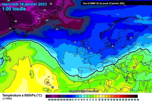
Met Eireann has issued a Winter Weather Advisory for Ireland with temperatures set to drop from Sunday through Thursday next week.
According to the forecast, it will turn cold across the country on Sunday evening and Thursday as an Arctic airflow becomes established.
Saturday night: Cold and breezy at first with scattered showers, with some wintry falls possible on high ground. Driest and clearest overnight in the south and east. Fresh and gusty westerly winds will gradually ease in most areas through the night but will remain strong in the southwest. Lowest temperatures of -2 to +2 degrees, with frost and icy stretches developing.Sunday: Sunday morning will be mostly cloudy in Connacht, Munster and south Leinster with showers or longer spells of rain. sunny spells in Ulster and north Leinster, but showers will develop here also through the day, some of hail with isolated thunderstorms possible. Highest temperatures of 4 to 7 degrees with mostly moderate westerly winds.Sunday night: Showers will mostly become confined to northern counties overnight with clearer weather developing elsewhere. Some falls of sleet likely, falling as snow later in the night in the north. Widespread frost will form with ice on untreated surfaces. Lowest temperatures of -3 to -1 degrees. Pockets of freezing fog will also form in light winds, westerly becoming northerly.Monday: Frost or ice will linger in some parts during the day. There will be sunny spells with wintry showers, some of hail, feeding onto northern facing coasts in a light northwest airflow, and also into the southwest. Turning cloudier with showers possibly becoming more widespread later. Widespread sharp frost with temperatures falling to -3 or -4 degrees, possibly colder locally. Clear spells with scattered wintry showers. Some freezing fog will likely form with little wind.Tuesday: Cold with lying frost or ice. Afternoon temperatures of just 1 to 3 degrees. A mostly bright day with showers continuing to feeding into Atlantic and northern areas in a northerly airflow, freshening later. Lowest temperatures of 0 to -3
Wednesday: Sunny spells with scattered wintry showers. Highs of 3 to 6 degrees but feeling very cold in a brisk northerly wind. Temperatures will likely fall below zero again on Wednesday night.
Further Outlook: Turning much milder on Thursday with a spell of rain and fresh southwest winds moving in from the Atlantic. Staying mild and changeable for the rest of the week.